Welcome to the official website of SEASTARS CORP.,LTD.
Simulation scheme of infrared photoelectric multispectral imaging
- Categories:Electronic System Simulation
- Author:
- Origin:
- Time of issue:2021-08-23 09:45
- Views:
(Summary description) This program is designed for the design and development, modeling and simulation, simulation and training of infrared, night vision, photoelectric and radar sensors on various operational platforms, my company based on the real physical model of the infrared, radar modeling simulation software SensorFX, RadarFX as the basis for secondary development, the implementation of a number of successful cases.

Simulation scheme of infrared photoelectric multispectral imaging
(Summary description) This program is designed for the design and development, modeling and simulation, simulation and training of infrared, night vision, photoelectric and radar sensors on various operational platforms, my company based on the real physical model of the infrared, radar modeling simulation software SensorFX, RadarFX as the basis for secondary development, the implementation of a number of successful cases.
- Categories:Electronic System Simulation
- Author:
- Origin:
- Time of issue:2021-08-23 09:45
- Views:
1. Programme overview
This program is designed for the design and development, modeling and simulation, simulation and training of infrared, night vision, photoelectric and radar sensors on various operational platforms, my company based on the real physical model of the infrared, radar modeling simulation software SensorFX, RadarFX as the basis for secondary development, the implementation of a number of successful cases.
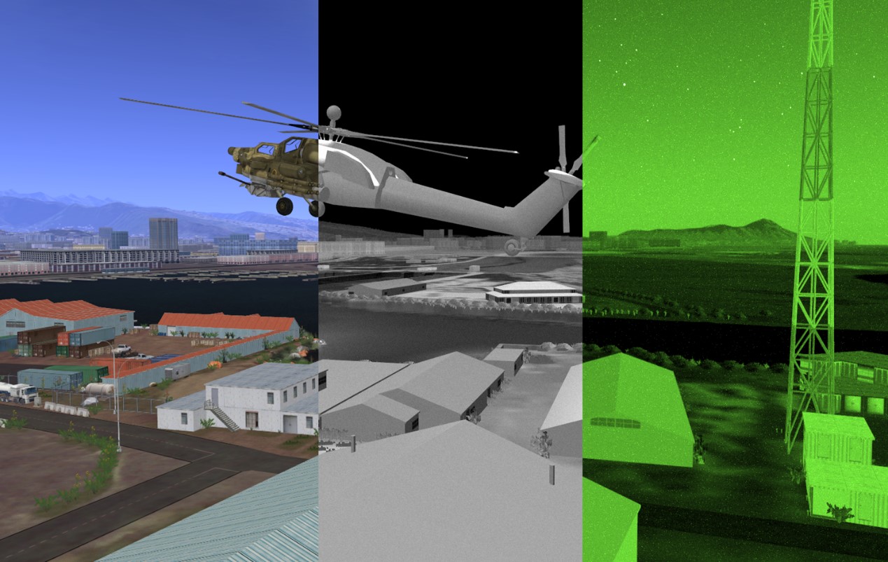
Figure 1 visible/infrared/night vision composite image
2. Introduction of the scheme
2.1System structure

2.2Module introduction
2.2.1Infrared materials classification tool GENESIS
Based on the real physical process, the physical modeling of self-radiation and thermal reflection of typical materials in 0.2-25.0 μm Band is realized.
2.2.2Atmospheric thermal conductivity modeling tool SIGSIM
First, various models of natural or artificial light sources, such as daylight, moonlight, tungsten, sodium, and Neon, are included. Second, atmospheric infrared transmission is modeled and configured using the Modtran and Radtran Algorithms approved by the United States Department of Defense, the second is to support the thermal radiation reflection characteristics of the modeling and simulation.
2.2.3Infrared sensor modeling tool SENSIM
PROVIDE EO & Ir Band Optical Sensor Simulation, built-in a variety of commonly used real standard sensors, Ikonos satellite and Landsat satellite;
2.2.4Distributed simulation tool set VT-m äk product line
The SensorFX and Radarfx plug-ins integrated in VR-Vantage can be deeply integrated with VR-Forces, GL-Studio and so on through HLA/DIS protocol to build many different applications.
3. Technical characteristics
1. The software can realize the real-time simulation of high-end FLIR and NVG, and can participate in the battlefield simulation federal environment based on Hla or DDS
2. Can Be embedded in the VR-Vantage powerful sensor module, including the advantages of the VR-Vantage, such as convenient angle switching function;
3. It is suitable for simulating any photoelectric/infrared sensor in 0.3-16.0 μm band
4. The software has a signal processing and atmospheric environment module following the actual physical process, and the simulation mechanism is real and credible
5. The software can produce industrial level sensor simulation and simulation effect, so it can be used in the field of simulation training.
4. Application scenario
1、Infrared night vision
A forward looking infrared camera simulation system for the navigation and targeting equipment of a certain type of helicopter, integrated in a larger flight simulator, is used for the training and simulation of aircraft navigation and searching and capturing targets for night flight and attack, provides precision guidance and targeting for guided and unguided weapons.
2、Air Reconnaissance and early warning
Unmanned Aerial Surveillance and early warning program. The Unmanned Aerial Vehicle and reconnaissance helicopters carry infrared cameras, infrared scanning devices and other equipment to carry out reconnaissance and surveillance of enemy forces and their activities, positions, terrain and other conditions.
Category: Electronic System Simulation
Scan the QR code to read on your phone

Contact Us
14th Floor, Block A, China International Science & Technology Exhibition Center, 12 Yumin Road, Madian, Chaoyang District, Beijing
