Welcome to the official website of SEASTARS CORP.,LTD.
Landscape database solution
- Categories:Simulator
- Author:
- Origin:
- Time of issue:2021-08-19 18:30
- Views:
(Summary description)IMMERSIVE “Real geographical environment”roaming is a comprehensive subject, which needs the close combination of graphic graphics and geography. Geography gives a true geographic description of a region, which is reflected by data in a certain format and with a certain degree of accuracy; graphic imageology reorganizes this data using graphic hardware and software techniques, the geoscience description data is dynamically restored on the computer platform to complete the roaming “Real geographical environment”. This is one of the joint points formed by the continuous development of the two disciplines. In recent years, the technologies supporting terrain generation and massive texture scheduling in graphics and imageology have developed rapidly and become mature, and the computer processing ability has been greatly improved, so that the construction of the “Real Geographical Environment”of the visual scene has a technical guarantee. The digitization of basic geographic information data and the development of satellite remote sensing systems also provide data support for this purpose.

Landscape database solution
(Summary description)IMMERSIVE “Real geographical environment”roaming is a comprehensive subject, which needs the close combination of graphic graphics and geography. Geography gives a true geographic description of a region, which is reflected by data in a certain format and with a certain degree of accuracy; graphic imageology reorganizes this data using graphic hardware and software techniques, the geoscience description data is dynamically restored on the computer platform to complete the roaming “Real geographical environment”. This is one of the joint points formed by the continuous development of the two disciplines. In recent years, the technologies supporting terrain generation and massive texture scheduling in graphics and imageology have developed rapidly and become mature, and the computer processing ability has been greatly improved, so that the construction of the “Real Geographical Environment”of the visual scene has a technical guarantee. The digitization of basic geographic information data and the development of satellite remote sensing systems also provide data support for this purpose.
- Categories:Simulator
- Author:
- Origin:
- Time of issue:2021-08-19 18:30
- Views:
IMMERSIVE “Real geographical environment”roaming is a comprehensive subject, which needs the close combination of graphic graphics and geography. Geography gives a true geographic description of a region, which is reflected by data in a certain format and with a certain degree of accuracy; graphic imageology reorganizes this data using graphic hardware and software techniques, the geoscience description data is dynamically restored on the computer platform to complete the roaming “Real geographical environment”. This is one of the joint points formed by the continuous development of the two disciplines. In recent years, the technologies supporting terrain generation and massive texture scheduling in graphics and imageology have developed rapidly and become mature, and the computer processing ability has been greatly improved, so that the construction of the “Real Geographical Environment”of the visual scene has a technical guarantee. The digitization of basic geographic information data and the development of satellite remote sensing systems also provide data support for this purpose.
Related Technology:
Satellite Remote Sensing System and other basic geographic information
texture compression technology LOD technology
page scheduling technology
APPLICATIONS:
Now the application of geodesic database is more and more extensive, providing users with more intuitive, more realistic three-dimensional scenes. At the same time, the relevant application industry is maturing according to user needs, and can be divided into the following three areas: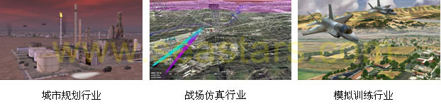
DEVELOPMENT PROCESS:
The development of “Real geographic environment”simulates the real world by constructing virtual scenes, and simulates observing and browsing the real world by controlling the virtual scenes interactively. When we develop the 3D visual database, we need to use the tools of graphic editing, 3d modeling and 3D database making. According to the collected digital elevation data, we add texture and map cultural features, load the 3D model to build a complete visual database. The development process is as follows: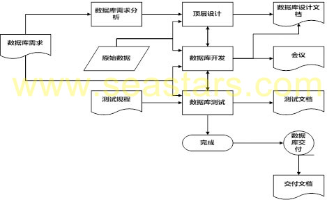
As can be seen from the diagram above, the database development process mainly includes: database requirement analysis, raw data collection, top-level design, database development, database testing, database delivery and other important steps, we’ll go through these steps and work on them in more detail below.
Database Requirements Analysis:
First of all, it is the starting point of all the work, that is, the users provide the database requirements. At this stage, a database needs assessment is needed to determine the correctness and feasibility of the requirements. The users and the database engineers need to meet, the two sides communicate on the database construction requirements to ensure that the two sides understand the database construction requirements are the same. In general, the user needs to provide a job description and a detailed description to the database build engineer. In addition, the database build engineer can obtain some information about the requirements from other sources, for example: Simulator Training topics related to professionals (pilots) and so on.
After the database creation engineer has identified the database development requirements, it is necessary to provide timely feedback to the users and confirm the requirements to ensure that there is no inconsistency in understanding, and to form a database working group, facilitate users to evaluate the progress of the database and provide timely feedback to users on the progress.
Top Level Design:
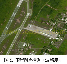
All of the design work will be determined before the user needs as a starting point, to ensure that the final result can meet the user’s requirements. During the design phase, we will determine all aspects of the terrain based on the user’s simulator training tasks, such as terrain fineness, location and requirements of key areas, database relevance and interoperability requirements, visual distance, atmospheric conditions, et CETERA. In addition, for different users, there will be some special requirements for the database, such as: The location of the landscape database, latitude and longitude information, the database starting point, as well as the coverage area, the database seasonal information, all special airport models, dynamic models, feature data models, and user-generated raw data requirements. During the design phase, the database creation engineer determines the database development process and standards based on the database development requirements, and archives this information to the end user. Raw data collection: mainly for the needs of users and simulator training objectives, to collect the raw data needed to create a database, there are mainly the following categories: satellite image data: ground map used to create a landscape database, generally using 1M, 5m, 15m three kinds of precision satellite images, the coverage area size as well as the precision request may also carry on the corresponding adjustment according to the user request. 1m satellite images mainly cover the vicinity of the airport and the main area, to provide a more detailed ground map for flight, to facilitate pilot identification of some feature sites or feature buildings; 5m satellite image provides medium precision ground map effect, which is mainly used as the transition area between 1M satellite image and 15m satellite image, and 15m satellite image provides low precision ground map effect, mainly is lets the pilot be able to observe when the high altitude flight the approximate topography effect, the coverage area is big.
Topographic elevation data:
The data containing terrain elevation information, the size must cover the simulator training used by the entire region, the accuracy of the size can be determined by user requirements, in general, the use of 90m accuracy data can be.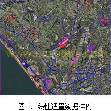
Vector Cultural Feature Data:
Users create regional vector feature data, mainly buildings, roads, rivers, oceans and other information, according to user needs to purchase.
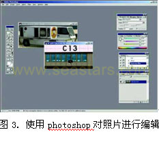
Photo Data:
In general, when doing 3d modeling, especially when some key buildings or key models, we need to take some photos for the real object, and use them as the texture materials to achieve the real visual effect.
Database Development:
Airport data authentication:The main task of the airport data appraisal stage is to compare the position, latitude and longitude, fineness, effect, season, color, coverage area and other information of the data obtained with the user’s request after obtaining the corresponding data, and to confirm that the data are correct, get ready for the next step. At this stage, it is often necessary to confirm the data with the user several times to ensure that the final result can meet the requirements of the customer.
Focus Area 3D modeling:
The main task of this stage is to carry out 3D modeling for the key area (usually the airport in flight simulation) proposed by the customer. The main steps in the process are described in more detail below.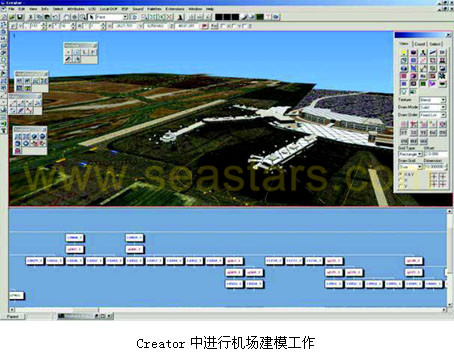
3D LANDSCAPE DATABASE GENERATION:
The construction of 3D landscape database in landscape database modeling software mainly includes two aspects: Landscape data processing and vector characteristic data processing. The reason for this is that the general SGI Visual Workstation system has its own data format, and all data (including satellite image data, elevation data, vector data, etc.) need to be imported through the landscape database modeling software, format conversion. The data is specially optimized for the SGI Visual Workstation system, so there will be a big improvement in both speed and display, during the import process, we can set the relevant parameters according to the user’s needs, for example, by setting the number of layers when data is imported to determine the level of detail for satellite image call-up, by setting the compression method to determine the effect of the calculated data and the size of the data, and so on, to achieve user requirements under the premise of trying to improve the efficiency of the system.
The loading of the landscape database is mainly to set up the configuration file and load and debug some key models, which are all done in the database modeling software.
Database testing:
In this stage, the main work is to have completed the database on the graphics generation system to run, to see the actual results. Database testing plays an important role in the entire database production process: on the one hand, the effects seen during the production phase may deviate from the actual effects run on the graphics generation system (Color Effects, light points, texture fineness, including the impact of the projection system on the final result, etc.) , we need to make some changes and adjustments to the database according to the actual effect of the test to meet the requirements of the final effect. On the other hand, many graphics generating systems have their own special effects, such as motion texture, building collision detection settings, light orientation settings, light marshalling control, animation playback, and so on, the final effect can only be seen when running on the graphics generation system, we can not see when creating in Creator, all these need to be tested in this stage, to evaluate the final effect, check to see if the final requirements of the user are met. In addition, we may have some problems in the creation process, which can help us find some modeling errors in the testing phase, such as the use of concave polygons, some of the model surface is invalid, MAP format errors, too many map serial numbers, errors in datum setting, and so on. These problems can only be found after actual testing, and during the testing phase we can know the specific problems and modify them accordingly, instead of blindly looking for it. Most importantly, at this stage, users can be more involved, because they are the judges of the final effect, even before they did not notice the problem can be found in the test phase, timely change; Or The user has the new demand and the change, can propose in the test phase, carries on the prompt change and the adjustment, guarantees the final delivery effect.
Database delivery:
After the user accepts the signature during the test phase, the database is officially delivered to the customer. In addition to the database files, we generally deliver the source data drive to the user, and in the following time, if the user needs, can modify the existing database, maintenance and related technical support work.
Category: EMULATORS
Scan the QR code to read on your phone

Contact Us
14th Floor, Block A, China International Science & Technology Exhibition Center, 12 Yumin Road, Madian, Chaoyang District, Beijing
